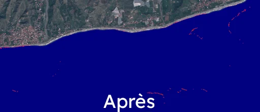
Ocean Plastic Alert & Tracking

Born from the desire of Geomatys employees to design a geospatial service useful in the environmental fight, OPAT (Ocean Plastic Alert and Tracking) is a system for alerting and detecting plastics at sea, with anticipation of their potential drift. This project, built on Examind Datacube, enables spatio-temporal analysis of geospatial data and consequently a prediction of plastic waste drift.

Plastic waste and coastlines: the issue

pexels-ron-lach-9034666 (1)

Globally, plastic waste is estimated to account for 85% of all marine litter, representing between 75 and 199 million tonnes — a quantity that some studies predict will triple by 2060. 

On coastlines, municipalities are spending up to several million euros per year cleaning beaches. This issue also clearly affects the tourism sector, since the presence of waste on beaches at seaside resorts naturally harms their reputation: studies estimate that coastal waste can reduce the overall revenue of tourist areas by up to 5%.

Acting upstream with OPAT

This is the objective of OPAT. By using geospatial imagery and passing it through detection algorithms developed and integrated into Examind Datacube, we are able, through hyperspectral imagery, to precisely determine the location of plastic waste patches.

The idea is therefore to anticipate the arrival of plastics on the beach, in order to reduce cleaning costs, but also to improve the image of beaches for tourists. Moreover, plastic is easier to recycle when collected at sea than when retrieved contaminated by sand on the beaches.

Examind Datacube enables the management of large volumes of geospatial data, and consequently gives us the ability to perform spatio-temporal analyses. Furthermore, the ocean current experts mobilized through the project enhance the quality and relevance of the drift predictions that Geomatys has already implemented, notably through projects with JAXA. The historical collection data is then used to improve drift predictions using Machine Learning. Indeed, the vessel collected debris at a position X,Y and a time T, which differs from the time our algorithm detected the debris, as the latter is linked to the satellite's pass over the area.

Déchets collectés en mer grace a OPAT
Résultats d'une collecte des déchets en mer à St-Jean-de-Luz

Comment fait-on ?

Our partners

Logo_CNES_2017_triangulaire_bleu
1024px-ESA_logo
Logo_Occitanie_2017.svg
DATATERRA-logo

Nos récompenses

En novembre 2023, OPAT a remporté le Prix CASSINI, décerné par l’EUSPA. Ce Prix récompensait la meilleure solution commerciale tirant profit des données géospatiales de l’UE

Contact Us

OPAT Vous intéresse ? Une envie de devenir partenaire ? Contactez nous !